
Assahafa.com
B.C. is expecting an influx of wildfire evacuees from Alberta, even as it deals with wildfires of its own.
On Monday night, officials ordered the township of Jasper and surrounding national park to evacuate using Highway 16 into British Columbia due to a fast-approaching wildfire.
In a post on X, B.C. Emergency Management Minister Bowinn Ma said the province would do “everything we can to provide safe refuge for evacuees” and that officials were working “as quickly as possible to coordinate routes and arrange host communities” to take people in.
Wildfires in the region has also closed Highway 16 from Tête Jaune Cache toward the Alberta border, covering Mount Robson Provincial Park.
Comment on articles, stay in the know with our newsletters and stream more on CBC Gem.
DriveBC says the highway will remain open westbound, as wildfires cause people in Jasper, Alta., to flee west into B.C. on Monday.
UPDATED
Wildfire threatening Jasper National Park and town prompts evacuation order
The order comes as B.C. experiences heavy thunderstorms and high winds in parts of the province already dealing with out-of-control wildfires.
Severe thunderstorm warnings are in place for the Interior and north, including in the Cariboo where wildfires are threatening the communities of Wells, the historic town of Barkerville and parts of Williams Lake.
The warnings also apply to the Peace River region from Mackenzie to Tumbler Ridge, the Williston and McGregor areas and the Lakes District.
Winds of up to 45 kilometres, heavy downpours and hail the size of nickels or even ping-pong balls are all possible, the warning says.
“The forecasted wind has the potential to increase fire behaviour on any wildfires currently burning and new starts could grow quickly,” the B.C. Wildfire Service said in a statement.
“Strong winds developing around thunderstorms can also result in erratic fire behaviour. The hot and dry conditions will support overnight burning in the southern half of the province.”
In a post on X posted earlier in the day, the weather agency also warned a tornado could develop over the Williston area in the northeast, near Tumbler Ridge, B.C. and the McGregor area in the Cariboo. However, the warning was not included on the agency’s website.
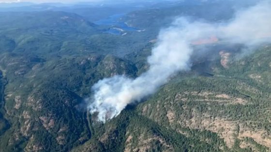
The warnings come as more than 300 wildfires are burning across B.C. after a volatile weekend that saw hundreds of people told to leave their homes and lightning strikes starting new burns throughout the B.C. Interior.
The Ministry of Emergency Management and Climate Readiness said as of early afternoon Monday, there were about 440 properties on evacuation order and 3,000 under alert, calling the situation “dynamic and everchanging.”
Tracking wildfires in British Columbia
Several detours are also in effect due to wildfires, with the Ministry of Transportation warning more roads and highways could be closed with little notice. Drivers are advised to visit drivebc.ca for the latest information.
Vancouver Island park closed due to human-caused wildfire
On Monday afternoon, Sooke Potholes Park on Vancouver Island was closed due to a wildfire detected near Mavis Lake east of Victoria.
The B.C. Wildfire Service says the fire is believed to have been human-caused, a broad category referring to any wildfire not sparked by lightning.
The Capital Regional District said as a precaution, campers are being evacuated and the public is asked to avoid the area.
In an interview with CBC News shortly before 5:30 p.m. PT, Sooke Mayor Maja Tait said there is currently no risk to the wider community, but as a precaution, the district has cancelled a scheduled council meeting so it can react if anything changes.
Historic gold rush town evacuated
On Sunday, the historic gold mining town of Barkerville — the centre of the Cariboo Gold Rush of the 1860s, which helped shape the province of British Columbia — was ordered evacuated due to the threat of the rapidly growing Antler Creek wildfire.
Located about 180 kilometres southeast of Prince George, Barkerville is the largest living history museum in North America.
That same fire also forced the evacuation of the Bowron Lake provincial park canoe circuit and the artistic enclave of Wells, impacting up to 1,000 residents, tourists and temporary workers, according to Mayor Ed Coleman.
On Monday evening, the B.C. Wildfire Service said the fire had expanded to 32 square kilometres and was now just three kilometres from Wells and Barkerville.
It said it had managed to establish control lines and a “humidity bubble” in Barkerville and the surrounding area to minimize the risk of the old, wooden buildings burning.
The service said it was expecting the fire to increase in size in the coming days, as it could merge with other, samller burns in the area.
Fallen tree sparks fire in Williams Lake
Farther south, the city of Williams Lake, B.C., home to more than 10,000 people, ordered a local state of emergency Sunday night after a fire broke out along Mackenzie Avenue, which is a strip of businesses and industry. The city’s emergency operations centre said the fire was sparked after a tree fell on power lines.
Locals posted photos and video of water bombers flying low over the neighbourhood on Sunday evening, and by midnight Mayor Surinderpal Rathor confirmed residents who had been “tactically evacuated” from their homes were allowed to return.
Crews moved fast to try to protect businesses and homes from a wildfire that broke out in Williams Lake, B.C., on July 21.
In a Monday morning update posted to Facebook, Rathor said that the fire was still burning in the city’s river valley “and making its way up the far side.” He also said part of an “unoccupied structure” had been lost.
Read more: Drones, water access banned in Williams Lake as wildfire burns.
Fire near Spences Bridge expected to grow
Other wildfires of note include the Shetland Creek fire, last measured at 200 square kilometres, which has put thousands of people on alert in the Ashcroft area west of Kamloops after forcing evacuations on Friday.
The wildfire forced the closure of Highway 1 between Ashcroft and Spences Bridge throughout Monday. The next update is expected at 12 p.m. PT on Tuesday.
The Aylwin Creek and Komonko Creek fires have forced hundreds of people to be asked to leave the area in the Central Kootenays.
According to Thompson Nicola Regional District representative Amanda Ellison, supports are being put in place for residents of the Spences Bridge area as further growth is expected on the Shetland Creek wildfire.
Heat warning, thunderstorm watch
Meanwhile, the province has extended heat warnings for much of the province’s Interior and north, warning of temperatures in the 30s during the day and the high teens overnight, while Environment Canada is forecasting continued smoky skies for the same regions.
Sunday saw more than 20,000 lightning strikes, according to the B.C. Wildfire Service and Monday could see more of the same with storms expected in all parts of the province except Vancouver Island and the south coast.
Your guide to B.C. wildfires: Maps, evacuation orders, air quality and more
B.C. Premier David Eby said Monday the government was bringing in all the resources it can to help people threatened by wildfires in the province.
“It’s an incredibly stressful time for a lot of British Columbians. We’ve got hundreds of people on evacuation order. We’ve got thousands on notice that they may need to evacuate their homes. And this is unfortunately, the beginning of the fire season that we were concerned about,” Eby said during an unrelated news conference.
Source: cbc